LADWP and DWR Joint Logos

Project

Information

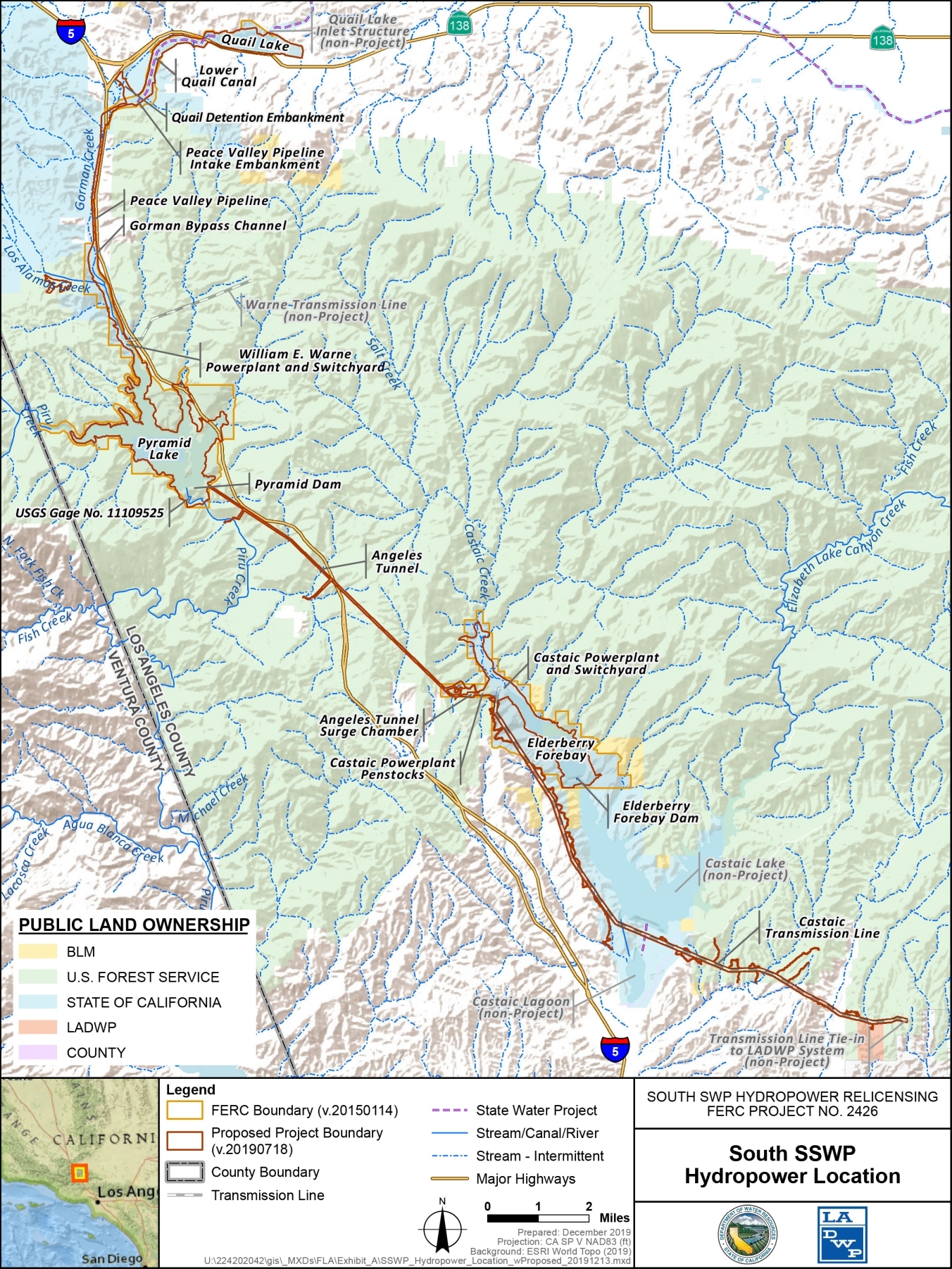
The South SWP Hydropower Project (Project) is located along a larger water storage and delivery system, the State Water Project (SWP), which is the largest state-owned and operated water supply project of its kind in the United States. The SWP provides southern California with many benefits, including affordable water supply, reliable regional clean energy, opportunities to integrate green energy, accessible public recreation, and environmental benefits. The Project, with a licensed installed capacity of 1,350 megawatts (MW), is located in Los Angeles County along the West Branch of the SWP.

The Project’s primary facilities range in elevation from 3,325 feet to 1,130 feet. The Warne Power Development facilities include Quail Lake, Lower Quail Canal, Peace Valley Pipeline Intake Embankment, Peace Valley Pipeline, Gorman Bypass Channel, William E. Warne Powerplant, Warne Transmission Line (owned and operated by Southern California Edison) and associated structures. The Castaic Power Development facilities include Pyramid Dam, Pyramid Lake, Angeles Tunnel and penstocks, Castaic Powerplant, Elderberry Forebay Dam, Elderberry Forebay, and Castaic Transmission Line.

Excluding the transmission lines, the Project’s existing Project boundary includes 6,928.0 acres of land, of which 2,807.28 acres are federal lands. Of the federal lands, 2,790.02 acres are within the Angeles and Los Padres National Forests under the U.S. Department of Agriculture, Forest Service (USFS), and are managed by the Angeles National Forest (ANF). The remaining 17.26 acres of federal lands are administered by the U.S. Department of the Interior (DOI), Bureau of Land Management (BLM).

Facilities Descriptions

  • Quail Lake

    serves as a forebay to William E. Warne Powerplant. Quail Lake has a normal maximum storage capacity of 7,583 acre-feet. When water is released, it flows from the lake through the two mile long Lower Quail Canal into Peace Valley Pipeline.
  • Peace Valley Pipeline Intake Embankment

    is an off-stream zoned earth and rockfill embankment with a single outlet from the Lower Quail Canal.
  • Peace Valley Pipeline

    serves as the penstock for William E. Warne Powerplant. The pipeline is 5.5 miles long.
  • Gorman Bypass Channel

    is a man-made channel that begins at the Peace Valley Pipeline Intake Embankment and extends downstream to Pyramid Lake, bypassing the William E. Warne Powerplant.
  • William E. Warne Powerplant

    generates power by taking advantage of the 725-foot drop through the Peace Valley Pipeline to Pyramid Lake. This plant has two generating units with an authorized installed capacity of 74,290 kilowatts.
  • Warne Transmission Line

    is a three mile, 220-kV transmission line extending from the Warne Switchyard to Southern California Edison’s Pardee-Pastoria Transmission Line. The line is owned and operated by Southern California Edison.
  • Pyramid Dam

    is located on Piru Creek. The dam is 1,090 feet long and has a height of 400 feet.
  • Pyramid Lake

    has a normal maximum capacity of 161,375 acre-feet and serves as an afterbay for Warne Powerplant and forebay for Castaic Powerplant.
  • Angeles Tunnel

    conveys water from Pyramid Lake to Castaic Powerplant and Elderberry Forebay in generating mode and conveys water to Pyramid Lake from Castiac Powerplant and Elderberry Forebay in pumping mode.
  • Castaic Powerplant

    is a pumping-generating plant and is located on the northern (upstream) end of Elderberry Forebay. There are seven units with an authorized installed capacity of 1,275 megawatts.
  • Elderberry Forebay

    is located directly downstream of Castaic Powerplant. Serves as an afterbay when the plant is in generating mode and as a forebay when the plant is pumping water back to Pyramid Lake. At a working elevation of 1530 feet, Elderberry Forebay has a gross storage capacity of 26,418 acre-feet.
  • Elderberry Forebay Dam

    is a zoned earthfill dam that is 200 feet high with a crest length of 1,990 feet. The Elderberry Forebay Dam is at the southernmost end of the South SWP Hydropower FERC license boundary.
  • Castaic Transmission Line

    is an 11.4 mile long, 230-kV transmission line extending from the Castaic Switchyard to Haskell Junction.

South SWP Hydropower Project Map

South SWP Hydroelectric Project Map